
Geophysical Survey
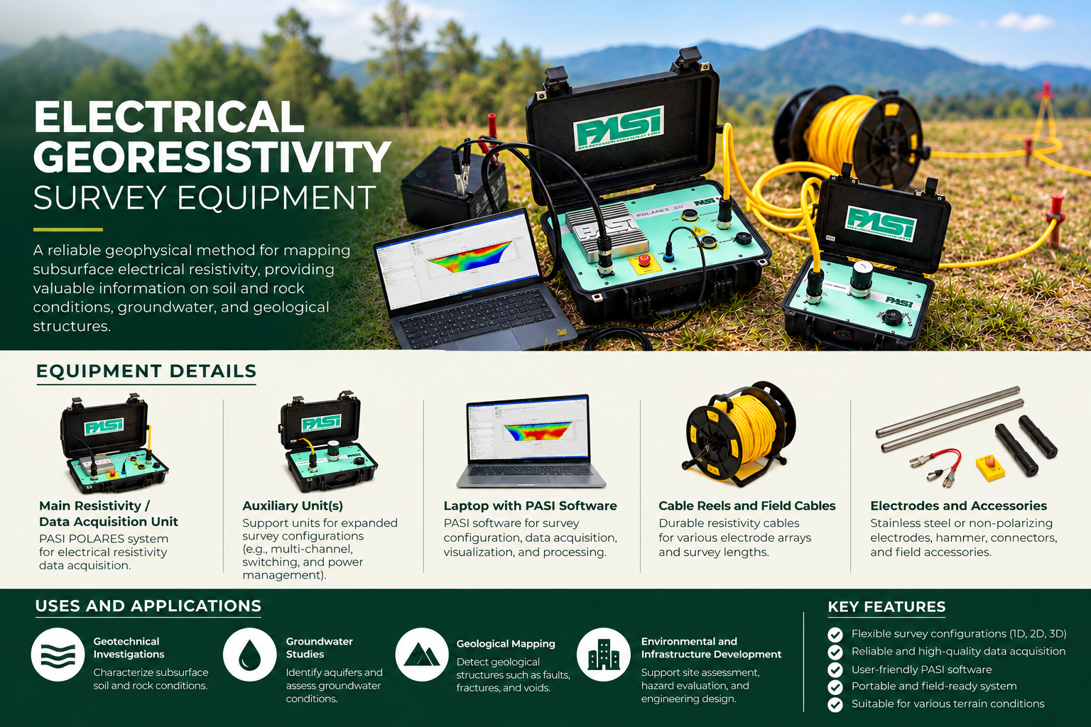
Electrical Georesistivity Survey Equipment – PASI POLARES System
The PASI POLARES Electrical Georesistivity Survey System is used for non-invasive subsurface investigations through electrical resistivity measurements. It supports geotechnical assessments, groundwater exploration, geological mapping, and environmental investigations by providing information on variations in subsurface electrical properties.
Equipment overview
How it supports an investigation
- **Equipment:** PASI POLARES Electrical Resistivity Survey System
- **Equipment Components**
- - Main electrical resistivity measurement and data acquisition unit
- - Auxiliary survey units
- - Field cable reels and electrical cables
- - Electrodes and connecting accessories
- - Laptop computer with survey acquisition and processing software
- - Field power supply and supporting accessories
- **Description**
- The PASI POLARES System is designed to measure subsurface electrical resistivity by introducing electrical current into the ground through electrodes and measuring the resulting potential differences. These measurements are processed and interpreted to characterize variations in subsurface materials and geological conditions.
- **Key Features**
- - Configurable electrode arrangements for electrical resistivity surveys
- - Digital measurement and data acquisition
- - Field-deployable equipment with supporting accessories
- - Computer-assisted data management and interpretation
- - Supports subsurface resistivity profiling and imaging, depending on survey configuration
- **Uses and Applications**
- - **Geotechnical Investigations:** Characterization of subsurface conditions to support engineering assessments.
- - **Groundwater Exploration:** Identification of potential water-bearing formations and investigation of subsurface hydrogeological conditions.
- - **Geological Mapping:** Assessment of resistivity contrasts associated with geological layers, fractures, weathered zones, and possible cavities.
- - **Environmental Investigations:** Supporting assessments of subsurface conditions and potential contamination pathways.
- - **Infrastructure Development:** Preliminary subsurface investigations for roads, buildings, foundations, and other engineering projects.
- **Survey Outputs**
- - Apparent resistivity measurements
- - Interpreted subsurface resistivity profiles or sections
- - Geological and hydrogeological interpretations, where supported by field data
- - Technical findings and recommendations for further investigation
- **Important Note**
- Electrical resistivity measurements provide indirect information about subsurface conditions. Interpretation should be supported by available geological, borehole, hydrogeological, or other site-specific information. Groundwater yield and water quality cannot be determined from resistivity measurements alone.
Services and applications
What GALERIO can do
- Uses and Applications
- Geotechnical Investigations: Characterization of subsurface conditions to support engineering assessments.
- Groundwater Exploration: Identification of potential water-bearing formations and investigation of subsurface hydrogeological conditions.
- Geological Mapping: Assessment of resistivity contrasts associated with geological layers, fractures, weathered zones, and possible cavities.
- Environmental Investigations: Supporting assessments of subsurface conditions and potential contamination pathways.
- Infrastructure Development: Preliminary subsurface investigations for roads, buildings, foundations, and other engineering projects.
- Survey Outputs
- Apparent resistivity measurements
- Interpreted subsurface resistivity profiles or sections
- Geological and hydrogeological interpretations, where supported by field data
- Technical findings and recommendations for further investigation
- Important Note
- Electrical resistivity measurements provide indirect information about subsurface conditions. Interpretation should be supported by available geological, borehole, hydrogeological, or other site-specific information. Groundwater yield and water quality cannot be determined from resistivity measurements alone.
Project-specific enquiries
Discuss a Technical Proposal
Tell us about your investigation requirements so GALERIO can discuss suitable methods and equipment for your project.